A guide for everything you need to know about Gatlinburg and the Smoky Mountains.
http://www.oldcreeklodgegatlinburg.com
Showing posts with label hiking trails. Show all posts
Friday, January 23, 2015
The Best Winter Scenery in The Great Smoky Mountains of Tennessee
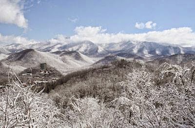
Whether or not you have ever walked the Great Smoky Mountain trails of Tennessee, there is nothing quite like visiting these trails in the winter. During the coldest months of the year, the Great Smokies get a healthy coating of snow, drastically changing the look, feel and landscape of the mountain trails. Visiting in the winter offers a very refreshing change from what may have otherwise been a drab and dull winter. If you choose to visit the Great Smoky Mountains of Tennessee during the winter, here are the best winter spots that offer the best scenery.
Laurel Falls Trail
Laurel Falls is one of the most popular destinations in the Great Smoky Mountains National Park. As a result, visiting this trail during the peak season makes it hard to find a parking spot. However, visiting during the winter months makes this trail much more enjoyable. You are also greeted by some of the most breathtaking scenery you have ever seen.
The Laurel Falls Trail was first established in 1932. It helped provide fire crews with easier access to the Cove Mountain area in case of a forest fire. By the 1960s, this spot became a popular hiking area because of its amazing views. Another thing that made it a popular trail was that it was paved in 1963 to prevent erosion. This has made it a go-to spot for families with young children and an easy place to hike during the winter.
Despite being paved, there are some high drop-offs along the trail that make it perfect for sightseeing. If you follow the trail for 2.3 miles, you eventually come to the 80-foot waterfall after which the trail was named. This is a beautiful site to see no matter what time of the year it is.
Rainbow Falls Trail
The Rainbow Falls Trail in the Great Smoky Mountains National Park is a fan favorite. Located in Sevier County, Tennessee, this trail ascends Mount Le Conte. No matter what time of the year you hike up the Rainbow Falls Trail, you are in for some fantastic scenery because Mount Le Conte is the sixth-highest mountain on the east side of the Mississippi River.
The first part of the Rainbow Falls Trail is a steady climb. Thankfully, there are some great opportunities along the way to stop for picnics and take in the scenery. Further along the trail, as you come up to LeConte Creek, you come across two footbridges. The view from there is always amazing, but even more so in the winter. Just 2.7 miles from the start of the trail, you come across a waterfall that is 80 feet high. Few things in life are as grand as laying your eyes on this beauty during the winter. Don't climb the rocks near the waterfall because, even during the summer months, they are slippery.
Alum Cave Bluffs Trail
Another trail that leads up Mount Le Conte is the Alum Cave Bluffs Trail. Hiking this trail in the snow is simply wonderful. During the early hours of the morning, it's unlikely that you will encounter other hikers, which really adds to the charm. One great thing about this trail is that it's covered in evergreens. This breaks up the scenery to create a view that you usually don't see during the winter. Just don't go down this trail expecting to find a cave. In fact, this trail got its name from a very unusual concave that formed along the trail, creating an overhang that goes right over the trail and heads up to a bluff.
This is an example of a trail that isn't too difficult to hike during the winter. The hardest part of the trail is near the natural arch. Here, there are stone steps that lead up to the rest of the trail. This part of the trail is known for getting really icy. There are cables that you can use to help climb the trail, but these get icy as well. Just take it one step at a time, and make sure of your footing before moving on.
Chimney Tops Trail
Chimney Tops is another popular area in the Great Smoky Mountains. This area is most well known for being one of the very few summits of bare rock. As you may know, most of the summits in the Great Smoky Mountains are covered in trees. Natural weathering has cleared and exposed the rock by stripping away soil. One reason why this is such a popular place to visit during the winter is because it doesn't require any kind of special gear to climb. Also, on clear days you can see the Sugarlands Valley to the north of the trail. Finding a clear day in the winter isn't too difficult.
Before heading out during the winter months to hike the trails of the Great Smoky Mountains, remember that it can be risky business hiking in the winter. Two of the most serious risks that you will face include dehydration and hypothermia. The best way to prevent running into any problems is to stay dry. This is a tip that is particularly helpful in the winter because the rise in elevation makes the air cooler than what most people expect. However, this doesn't mean you can't enjoy the Great Smokies in the winter; you just have to be more careful than normal. In the end, it's worth it because the winter scenery in the mountains is like nothing you have ever seen. Pictures don't do it justice. You have to see it with your own eyes!
Monday, May 12, 2014
Favorite Gatlinburg Hiking Trails
The Great Smoky Mountains National Park located in Gatlinburg, Tennessee, boasts breathtaking scenery, extraordinary waterfalls and a multitude of hiking trails.
For hikers accompanied by children and for newbies to the sport, Grotto Falls is the ideal place to get started. A unique feature of this adventure is the opportunity to walk behind a 20 foot waterfall. Hikers are treated to an unusual aura as they watch and listen to water cascading around them. Grotto Falls is a favorite haunt for salamanders. Especially in springtime, Trillium Trail is adorned with an awe inspiring display of wildflowers as far as the eye can see. This approximate three mile trek requires two to three hours to complete.
Situated on an actual Cherokee Indian Reservation, Mingo Falls, accessible via Pigeon Creek Trail, features a 20 foot waterfall that is said to be the tallest waterfall in the Smoky Mountains. Encompassing four-tenths of a mile, this trail's skill level is ranked moderate. To many visitors, part of the difficulty stems from the fact that a 159 step stairway must be ascended at the beginning of the trail which is estimated to occupy a 10 minute span of time. In addition to beautiful scenery, hikers have the opportunity to visit an authentic Cherokee Indian settlement.
Following the negotiation of a wooden bridge, the trek to Abrams Falls passes through the floor of Cades Cove Valley. The highlight of this is the site of a 20 foot tall waterfall whose water flows at an mindboggling rate of speed. No swimming is allowed in the pool at the base of Abrams Falls because of the dangerous currents its waterflow speed creates. While in the area, visitors are urged to take the time to visit a cabin erected by the hands of John and Lucretia Oliver. This ediface is deemed to be one of the earliest structures built in the Smoky Mountains.
Abrams Falls also features opportunities to sight black bears, white-tailed deer, groundhogs and raccoons. Visitors are urged to give a wide birth to any skunks they may encounter.
Cades Cove Valley is also home to Little Greenbrier School, an 1800s building that served as a one-room schoolhouse and as the worship center for a church.
Hikers are encouraged not to miss the chance to visit a working grain mill. Mingus Mill is a turbine powered grain grinding mill that has been in operation since 1886. Cornmeal is still sold there today.
For older hikers or those who are physically handicapped, Sugarlands Valley Nature Trail offers a half mile circle that is accessible by wheelchair. A guidebook is made available to visitors containing information relative to special points of interest along the way including the opportunity to view the exterior of several early 20th century structures that were used by the rich and famous as second or vacation homes.
Porter's Creek Trail is deemed to be an easy two mile trek amidst some very interesting attractions including the remnants of a Model T vehicle and a burial site. Visitors have the unique opportunity to enter a barn and cabin once frequented by Great Smoky Mountain Hikers Club members.
At an elevation estimated to be 6,643 feet lies Clingmans Dome that is the highest point in the entire state of Tennessee. Hikers who successfully reach the dome are rewarded with a 360 degree view of awesome scenery that is 20 to 100 miles away. Visibility varies depending upon fog density and other atmospheric conditions. Clingmans Dome over-look is often dubbed “the flying saucer of Tennessee.”
Featuring a unique growth area for spruce trees, at one point, Clingmans Dome intersects the world renowned Appalachian Trail that runs from Georgia to Maine.
The two and a half mile hike around Laurel Falls is a mecca for photography buffs. Named in honor of the profusion of mountain laurel shrubs, Laurel Falls offers a unique opportunity for hikers to rest their feet and have fun at the same time. Some 30 canopy trees are the scene for a zipline adventure of a lifetime achieved at speed rates estimated to top 40 miles per hour.
Hiking around Laurel Falls is worth time for those desiring a relatively easy trek along mostly paved trail; however, prominently displayed signage is present cautioning hikers of dangerous conditions they will encounter should they elect to wander off the clearly marked pathway.
Hiking trails through the Great Smoky Mountains of Tennessee are rated on a scale of difficulty ranging from 0-5 easy, 5-10 moderate and 10+ for trails that should only be negotiated by experienced hikers and others are deemed to be in top-notch physical and mental health.
Ranked slightly above 10, specifically 10.59 on the difficulty scale is Middle Prong Trail commencing as a gravel trail along the banks of one of the Little River branches. This trail requires hikers to climb for 2.3 miles. The trail continues for another 1.8 miles before connecting with other more strenuous trails in the area.
Subscribe to:
Posts (Atom)